RESEARCH EXPERIENCES FOR UNDERGRADUETS IN RESILIENCE AGAINST EXTREME WEATHER EVENTS
RESEARCH TOPICS
1. Enhancing Rural Transportation Systems through Advanced Technology and Safety Innovations
Faculty Mentor: Ren Moses
Overview: This project aligns with the R-SEAT Center’s core focus areas: Innovation & Technology, Transportation Safety, and Resilience in Rural Multimodal Transportation Systems. The goal of this research is to evaluate and model data-driven solutions that improve safety, accessibility, and infrastructure resilience across rural transportation networks.
Student Activities:
- Collect and process rural transportation data, such as mobility patterns, traffic safety records, and sensor or GIS datasets.
- Evaluate advanced technologies and computational or simulation tools aimed at improving rural transit efficiency and infrastructure safety.
- Document findings in a technical summary, contribute to workforce development efforts, and prepare a poster or presentation for the final REU showcase.
Intellectual Merit: This project will advance understanding of how data-driven tools and emerging technologies can address the distinct safety and accessibility challenges of rural transportation networks, which are often underrepresented in transportation research. The student will apply data analysis and simulation to assess the effectiveness of candidate solutions.
Broader Impacts: Rural communities face higher crash fatality rates, longer emergency response times, and limited transportation alternatives during disruptions. Findings can inform transportation agencies and local governments in prioritizing investments that improve rural safety, mobility, and resilience. The student will gain hands-on experience in transportation data analysis and technology evaluation.
2. Agentic AI for Wildfire and Hurricane Impact Prediction and Evacuation Decision Support
Faculty Mentor: Eren Erman Ozguven
Overview: Wildfires and hurricanes can rapidly disrupt communities and transportation systems through road closures, infrastructure damage, and population displacement. Extensive hazard, weather, transportation, and demographic data are available, but turning them into timely information for emergency decisions remains challenging. Recent advances in large language models (LLMs) and agentic AI offer a way to automate this process. This project will develop an agentic AI framework for wildfire and hurricane impact assessment and evacuation decision support. Specialized AI agents will retrieve and analyze hazard information, identify exposed communities and transportation infrastructure, evaluate roadway accessibility, and support evacuation planning. Wildfire analysis will consider historical fire occurrence, vegetation, and weather; hurricane analysis will incorporate storm tracks, precipitation, storm surge, wind, and flood exposure. The project will culminate in a prototype decision-support system that lets users query hazard conditions, infrastructure exposure, and evacuation strategies.
Student Activities:
- Collect and process open-source hazard, transportation, and population datasets.
- Conduct geospatial and machine-learning analyses to identify vulnerable areas and potential disruptions.
- Develop AI agents for tasks such as hazard-data retrieval, exposure analysis, and roadway accessibility assessment.
- Create maps and visualizations to communicate results.
Intellectual Merit: This project advances research at the intersection of agentic AI, geospatial analysis, transportation resilience, and natural-hazard management. A key contribution will be examining how LLM-based agents can work with quantitative geospatial and machine-learning tools while keeping recommendations traceable to the underlying data. The project will provide a foundation for adaptive and interpretable AI-assisted systems for multi-hazard transportation and evacuation planning.
Broader Impacts: The framework can help emergency-management agencies, transportation agencies, and local governments identify vulnerable communities and infrastructure, evaluate accessibility, and explore evacuation alternatives, and it can be extended to other hazards and regions. The student will gain interdisciplinary experience in artificial intelligence, GIS, machine learning, transportation engineering, and disaster resilience through hands-on work with real-world datasets and Python-based analysis.
3. Evaluating Green Infrastructure for Stormwater Resilience Under Land-Use/Land-Cover and Climate Change
Faculty Mentor: Nasrin Alamdari
Overview: Urbanization and changing precipitation patterns can substantially alter watershed hydrology by increasing impervious area, reducing infiltration, and increasing stormwater runoff and peak discharge. Green infrastructure (GI), such as bioretention systems, permeable pavement, and bioswales, can reduce runoff and improve water quality. However, GI is commonly planned for present-day land-use and rainfall conditions, while its future performance may be affected by continued development and more extreme rainfall. This project will evaluate how land-use/land-cover (LULC) change and changing rainfall affect urban stormwater response and GI performance, addressing three questions: (1) How do changes in impervious cover affect runoff volume and peak discharge? (2) How does stormwater response change under more intense rainfall? (3) To what extent can GI offset increases in runoff under future LULC and rainfall conditions? A stormwater model (EPA SWMM, PCSWMM, or comparable) will be developed for a selected urban watershed, and performance will be evaluated using runoff volume, peak discharge, time to peak, and drainage-system exceedance.
Student Activities:
- Analyze land-use, soils, topography, precipitation, and drainage data for a selected urban watershed, and develop historical and future LULC scenarios from geospatial datasets.
- Develop or adapt a stormwater model for the study watershed.
- Simulate baseline conditions, LULC-change scenarios, rainfall scenarios, and selected GI alternatives.
- Evaluate and compare hydrologic performance across scenarios, and present results in a research poster, oral presentation, and technical summary.
Intellectual Merit: The project will examine the combined effects of urban development, rainfall change, and GI implementation rather than evaluating each factor independently. It will quantify how watershed sensitivity to changing rainfall depends on the extent and distribution of impervious surfaces, and whether GI designed for current conditions remains effective under future scenarios. The work will identify conditions under which GI performance begins to decline, and may include sensitivity or uncertainty analysis of key model parameters.
Broader Impacts: The research addresses a practical challenge for communities facing both urban growth and more extreme rainfall. Maps, model outputs, and performance metrics can support communication about stormwater resilience and inform GI planning and design under changing conditions. The student will gain interdisciplinary training in urban hydrology, GIS, environmental modeling, scientific visualization, and technical communication, preparing them for graduate study and careers in water resources and climate adaptation.
4. SmartRock Sensors for Real-Time Monitoring and Digital Characterization of Civil Engineering Materials
Faculty Mentor: Michael Elwardany
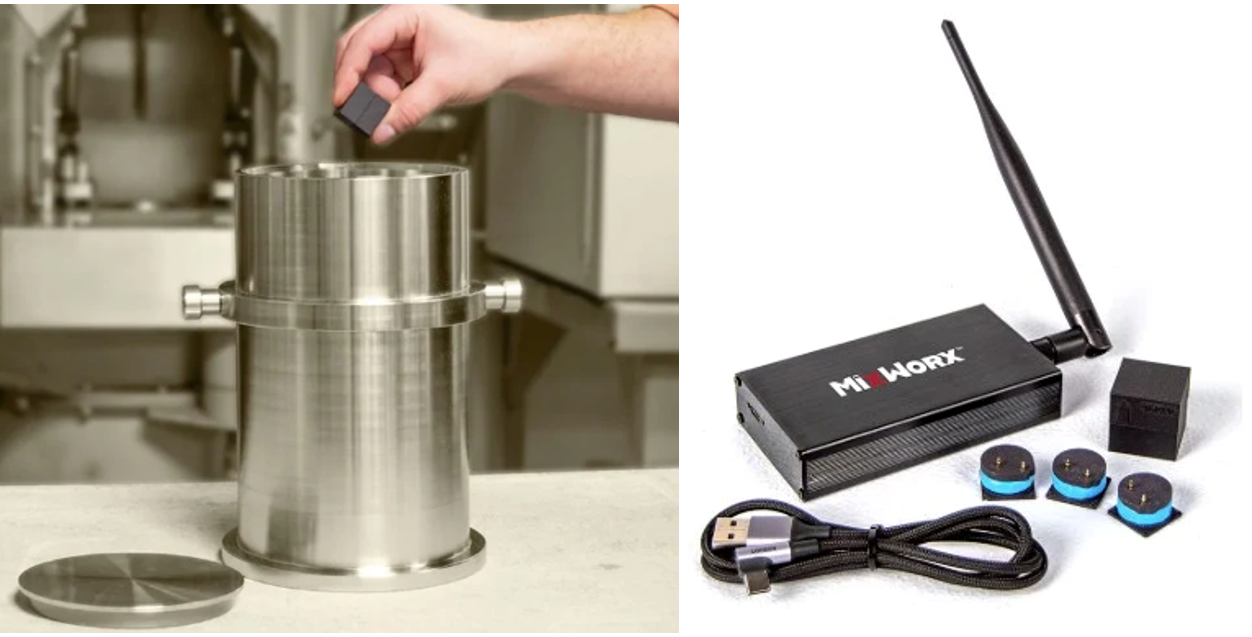
Overview: The construction industry is increasingly adopting smart sensing technologies to improve quality control, material characterization, and construction efficiency. This project will investigate SmartRock (MixWorx) wireless sensors as embedded tools for real-time monitoring of civil engineering materials, with a primary focus on asphalt mixtures. The sensor measures acceleration, rotation, and temperature during mixing and compaction, capturing material behavior that conventional tests miss. The research will explore how sensor-derived measurements can quantify workability, compaction efficiency, and material response, with emphasis on the influence of modifier type, compaction temperature, and aggregate structure on sensor signatures recorded during laboratory compaction. The project will also explore embedded wireless sensing for other materials, including concrete, geomaterials, and sustainable construction materials.
Student Activities:
- Conduct laboratory experiments on conventional and modified asphalt mixtures, including polymer-, rubber-, and sustainable material-modified systems.
- Collect sensor data during gyratory compaction and correlate it with density, air void content, and compaction curves.
- Apply statistical and data analytics methods to identify key sensing indicators and develop new metrics for mixture workability and constructability.
- Process, visualize, and model the data to support predictive analysis.
Intellectual Merit: This project will establish relationships between embedded sensor signatures and the compaction behavior of asphalt mixtures, an area not captured by conventional testing. New sensor-based metrics for workability and constructability will advance data-driven quality assurance methods for civil engineering materials.
Broader Impacts: Real-time sensing can improve construction quality and reduce premature pavement failures, supporting more durable and resilient infrastructure and emerging digital construction initiatives. The student will develop skills in civil engineering materials, sensing technologies, and AI-enabled data analysis, contributing to the next generation of intelligent infrastructure systems.
5. Causes of Flooding and Surface Water Pollution in River and Coastal Systems
Faculty Mentor: Ebrahim Ahmadisharaf
Overview: The goal of this research is to explore the space-time structure of hydroclimatic hazards: flooding and harmful algal blooms (HABs). We will develop frameworks that characterize and predict these hazards using historical satellite observations and ground measurements together with data-driven methods such as machine learning. The investigation will cover selected locations across the U.S. Gulf of Mexico and selected terrestrial watersheds in the U.S. The student will work with a large group of postdocs, graduate students, and undergraduates, with possible collaboration with other universities, NASA, USGS, ERDC, NOAA, and ORNL.
Student Activities:
- Build a database of hazard-influencing factors, such as precipitation, soil moisture, wind, storm surge, Karenia brevis, and chlorophyll-a, from public satellite and ground-measurement repositories.
- Conduct statistical analyses of these factors and their spatial and temporal dependencies to identify key causes of different hazards.
- Characterize coastal hazards in the region.
- Develop presentations and posters for symposiums and conferences (e.g., EWRI, AGU Fall Meeting, AMS Annual Meeting, and IGARSS).
Intellectual Merit: This project aims to fill the knowledge gap regarding the causes of hydroclimatic hazards, flooding and HABs, in the U.S. Gulf. The student will use novel statistical and geospatial analyses and satellite observations to address this gap.
Broader Impacts: Identifying areas at risk of flooding and excess water pollution will support adaptation planning and decisions that enhance the resilience of aquatic ecosystems, local communities, and physical infrastructure. Beyond conferences and peer-reviewed articles, results can be shared with national experts (e.g., USGS, USACE, and NOAA) through informal virtual meetings, and with the public through bay estuary programs and Cooperative Extension outreach and educational activities.
6. Effects of Terrain-Induced Wind Turbulence on Telecommunications Monopole Performance
Faculty Mentor: Sungmoon Jung
Overview: Telecommunications monopoles are widely used in urban, suburban, and rural environments and therefore experience wind flows shaped by very different upstream terrains. During high-wind events, these structures can experience excessive vibration, structural damage or failure, and reduced telecommunications performance due to antenna movement or misalignment. This project will investigate how terrain-induced differences in wind speed and turbulence affect the structural response of a telecommunications monopole, using measured wind time histories and finite element analysis.
Student Activities:
- Convert measured wind time histories representing different terrain conditions into time-varying wind loads.
- Apply these loads to a finite element model of a telecommunications monopole.
- Compare structural stresses, displacements, vibration, and antenna-level motion across terrain conditions.
Intellectual Merit: This project will clarify how upstream terrain, through its effect on wind speed and turbulence, governs the dynamic response of slender telecommunications structures. Using measured rather than idealized wind records will provide a more realistic assessment of structural and antenna-level performance than standard design approaches.
Broader Impacts: Telecommunications networks are critical for emergency communication during and after extreme wind events. Results can inform design and siting of monopoles to reduce failures and service disruptions, improving community resilience. The student will gain experience in wind engineering, structural dynamics, and finite element modeling.
7. ML-Assisted Structural Optimization of Flexible Structures Under Hurricane-Induced Wind and Wave Loading
Faculty Mentor: Pedro Hernández-Caban
Overview: During hurricanes, extreme wind and storm surge are the primary environmental forces acting on civil infrastructure in coastal regions. Lightweight, tall, and slender structures, such as transmission and communication towers and light poles, are especially sensitive to the variable and dynamic nature of wind and wave action, and predicting and optimizing their performance remains an ongoing challenge. This project will investigate novel machine learning (ML)-assisted optimization strategies that account for the combined effects of wind and waves and how these interactions affect coastal structures.
Student Activities:
- Perform a literature review to identify state-of-the-art numerical modeling approaches for combined wind and wave loads.
- Build finite element models (FEM) of different types of flexible structural systems to simulate their dynamic response under extreme wind and wave loads.
- Conduct a preliminary series of FEM simulations using high-performance computing.
- Assess the dynamic response of the structural systems and optimize their aerodynamic and hydrodynamic performance.
Intellectual Merit: Most design approaches treat wind and wave loads separately. This project will advance understanding of how combined wind–wave loading drives the dynamic response of flexible coastal structures, and how ML can make structural optimization under these coupled loads computationally practical.
Broader Impacts: Poles and towers support power, lighting, and communication networks that communities depend on during and after hurricanes. Better-optimized designs can reduce failures and speed recovery, strengthening coastal resilience. The student will gain experience in structural dynamics, finite element modeling, high-performance computing, and machine learning.
8. Durable and Resilient 3D-Printed Concrete Infrastructure
Faculty Mentor: Qian Zhang
Overview: Extrusion-based 3D concrete printing (3DCP) builds structures directly from a digital model with a robotic printer. It eliminates formwork, reduces waste and labor, speeds up construction, and enables complex geometries. These advantages make 3DCP promising for community resilience, including rapid rebuilding after hurricanes and other extreme events. However, printed concrete is built up layer by layer, which creates interfaces that can let chloride from seawater penetrate faster and corrode the steel reinforcement. This concern is pressing in coastal regions such as Florida, where storm surge, flooding, and sea-level rise increasingly expose infrastructure to saltwater. Because the printing toolpath controls where these interfaces form, this project will explore modifying interfaces to reduce the chloride that reaches the steel.
Student Activities:
- Fabricate 3D-printed concrete specimens with different interface arrangements using a robotic printer.
- Conduct durability tests to evaluate chloride penetration in printed and cast concrete.
- Conduct material characterizations to quantify chloride transport through the interfaces and bulk material.
Intellectual Merit: Earlier studies have shown that printing interfaces can accelerate chloride ingress. This project is the first to test whether interfaces can be deliberately altered to slow it down. The student will combine robotic fabrication, durability testing, and material characterization to establish relationships between interface structures and chloride transport.
Broader Impacts: Corrosion is one of the costliest causes of infrastructure deterioration, especially in coastal areas. This project would support more durable and resilient housing and infrastructure in coastal communities.
9. Prototyping and Assessment of a Virtual Engineering Lab
Faculty Mentor: Qianwen (Vivian) Guo
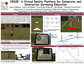
Overview: Hands-on laboratories are central to engineering education, but access to equipment, field sites, and lab time can limit how much practice students get. Virtual reality (VR) offers a way to extend these experiences. This project will develop and pilot a prototype virtual engineering laboratory in a lower-division undergraduate course and evaluate it for quality, usability, and suitability for instruction. The initial target course is CEG 2202L Intro to Geomatics Engineering, which covers computations and field procedures for measuring distances and angles with tape, level, transit, electronic distance measurement (EDM), and total station. A mixed-method assessment will be used: quantitative surveys to gather student ratings of the prototype, and qualitative feedback to identify areas for improvement. Through this iterative process, the project aims to produce a user-centered virtual lab that can be deployed in more classrooms.
Student Activities:
- Develop a prototype virtual engineering lab using VR technology.
- Pilot the prototype in CEG 2202L Intro to Geomatics Engineering.
- Collect and analyze quantitative and qualitative student feedback on the prototype.
- Refine the prototype based on the assessment results.
Intellectual Merit: This project will generate evidence on how VR-based labs affect student learning and engagement in engineering measurement courses. The mixed-method assessment will identify which design features make virtual labs effective, informing the development of virtual labs for other engineering courses.
Broader Impacts: Virtual labs can expand access to hands-on learning when equipment, field time, or in-person instruction is limited, including when extreme weather disrupts campus operations. A tested, user-centered prototype can be adopted in more classrooms to improve the learning experience of more students. The student will gain experience in VR development, user-centered design, and educational assessment.